
|
[Powered by |


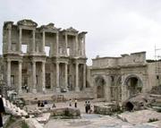
| Ephesus: Founded way back in the tenth century BCE, Ephesus boasts a remarkable history. During the reign of Augustus, the city emerged as one of the first five cities of the Ancient Roman Empire. It was crowned as the capital of the Roman province of Asia Minor, served as the headquarters of the Roman governor, and possessed one of the seven wonders of the ancient world: The Temple of Artemis, one of the largest temples of the Hellenic world. The city later blossomed into an important Christian center where St. Paul preached and St. John resided during the final years of his life. The Virgin Mary also resided here until her death. The first church built and dedicated to the Virgin is located in Ephesus, and in 431CE, it served as the meeting place for the Third Ecumenical Council. One of the most spectacular, restored edifices in Ephesus is the Celsus Library. Built by proconsul Tiberius Julius Aquila between 114 and 125 CE, this monument was dedicated to his father, Gaius Celsus Polamaenus. The structure served as a mausoleum as well as a library. The sarcophagus of Celsus is located in a large, central niche on the lower floor. The building embodies characteristics from the Imperial Age under Hadrian, who had a passion for architecture. The two storey facade is built using the Corinthian order. The columns are arranged in pairs, and between them there are three, richly decorated entrances. Statues in the niches between the doors are copies of the originals which are now in Vienna. Inscriptions on the bases indicate they symbolize the wisdom, knowledge, intelligence and virtue of the eponymous deceased. |
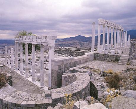
| Pergamon, Izmir: Almost all of the ruins on the present day acropolis of Pergamon, date from the Hellenistic period, when the kingdom of Pergamon was at the height of its power, and the city was a flourishing metropolis. The Temple of Trajan, however, is the only edifice which is genuinely Roman. It is thought that it was erected for Trajan by his successor Hadrian. Heads and other pieces of colossal marble statues of the two deified emperors discovered in the temple and moved to the Pergamon Museum in Berlin, are evidence that were both worshipped here. This temple, built to honor the cult of the deified Trajan, was originally constructed using thirty Corinthian style, marble columns. This ornate style is uses decorative acanthus leaves as the design motif on the top of the column, e.g., the capital. This was the favored style of the Romans. |


| Pamukkale: As you approach the site of Pamukkale / Hierapolis from Denizli, (only 20 km) a long white smudge along the hills to the north suggests a landslide or open cast mine. Getting closer, this resolves into the edge of a plateau, more than 100m higher than the level of the river valley and absolutely smothered in white travertine terraces. Pamukkale is one of the most extraordinary natural wonders in Turkey. Dozens of coaches daily make the long excursion, (three hours drive from Bodrum), Marmaris or Kusadasi. Stay over-night if you can to enjoy its tranquillity early in the morning or in the evening. The big attraction is a vast white cliff side with scallop-shaped basins of water and frozen waterfalls. It looks as if it s made out of snow or cloud or balls of cotton. The Turks have dubbed this geological fairyland Pamukkale (cottoncastle), from pamuk for cotton and kale for castle. A magical and spectacular natural site, unique in the world, Pamukkale is a fairyland of dazzling white, petrified castles. Thermal spring waters laden with calcareous salts running off the plateaus edge have created this fantastic formation of stalactites, cataracts and basins. The hot springs have been used since Roman times for their therapeutic powers. Both the thermal center with its motels and thermal pools, and the ruins of the ancient city of Hierapolis, are situated on the same plateau. The scientific explanation is that hot thermal springs pouring down the hillside deposit calcium carbonate, which solidifies as travertine. If you take off your shoes, you can gingerly roam the terraces or paddle in the pools. The entire territory of Pamukkale is at the center of particular attention on the part of the competent authorities who intend to safeguard the integrity and respect of this truly unique territory. Here, in a landscape fascinating in its own right, the action of various mineral springs which contain calcium oxides has left fantastic concretions on the travertine structures. The resulting effect is spectacular: these mineral-rich waters have dripped down over a series of terraced levels designing bizarre solidified cascades, dazzling in their radiance and changing their color according to how the sunlight strikes them. From a distance this whitish mass stands in evident contrast with the color of the surrounding uplands and brings to mind enormous stretches of cotton. On approaching this incredible succession of terraces, one discovers the existence of basins full of mineral water which flow into other natural basins below, and are the source of stupendous mineral conglomerations in the form of fantastic stalactites, sometimes of considerable size gild resembling organ pipes. The continuous dynamics of erosion and transformation of the natural landscape has resulted in an ambiance unequaled elsewhere and which constitutes one of the most unique phenomena to be found in nature. However, the misuse of waters has caused some of the formations to darken. Due to the ebb of waters caused by the excessive use for vicious interests Pamukkale often faces the danger of its color of cotton white. Against such potential dangers the local authorities and the Ministry of Tourism has adopted a series of measures, including the seizure of lands nearby. |

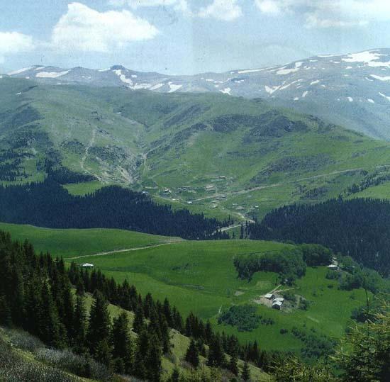
| The Sumela Monastery Throughout Anatolia there are many ancient churches either in caves or carved into the rock of a mountain. Archeologists point out that the Phrygian Kybele had many of her places of worship carved into the mountains. This custom is a carry-over from the time in which the Great Mother Goddess of Anatolia or one of her evolutionary types, of the Kybele-Kubaba class, had shrines in such locations. As the great biblical archeologist of the 19th and early 20th century, William Ramsay pointed out, pagan monasteries were located very close to the peaks of mountains for according to the classical belief-system, this location was the closest to the heavens, where the Gods and Goddesses were supposed to be. Prayers said in this environment had a short distance to travel to be fulfilled. Upon the advent of Christianity in Anatolia certain classical concepts were retained such as the location of heaven Pagan places of worship were easily converted into Christian ones by the sprinkling of holy water and the saying of prayers. When thinking of a lofty location for the setting of a monastery, Sumela Monastery at 1200 meters above sea level comes to mind. This monastery surrounding a cave church clings to a cliff. Resting precariously on a rocky ledge around 300 meters above a rockbound torrent, this striking monastic complex is 54 km. from the city of Trabzon on the Black Sea coastline. According to an ancient tradition, Sumela Monastery was established around 386 A.D. by two monks, Barnabas and Sophronius. Barnabas is believed to have had a dream of the Virgin Mary in which she instructed him to seek a cave on a narrow ledge situated on a palisade on the Black Sea and establish a monastery in her honor. He and his companion were guided by a famous icon reputed to have been painted by St. Luke, to a cave situated near a spring high up on the Zigana Mountains. The monastic settlement was known as "Our Lady of the Black Mountain". It has been a place of pilgrimage since very early times and it was honored by the Emperor Justinian who had the relics of St. Barnabas deposited in a silver reliquary there. The principal church of the monastery dedicated to the Assumption of the Virgin Mary was partially hewn out of the rock with the other part being a cave. This church was full of frescoes, one of which commemorated the coronation of Alexis II, which took place in 1340. Although its foundation, as we noted dates back to the 4th century, the surviving remains belong to the 13th and 14th centuries. The large monastery has five floors and 72 rooms. The upper floor was used as a gallery and a lookout post. The frescoes, which are paintings originally executed on wet plaster, still cover the facade and the interior of the so-called Cave Church. After centuries they are still bright and in fair condition considering the time that has passed. More recent paintings were done in the 18th century, however some of them have cracked revealing older frescoes underneath. There is a pool of holy water near the church, the source of which is in the overhanging rock which feeds the pool. During the early part of the 19th century, people would come to bathe in the pool, for it was reputed to have healing powers but today folks are content to drink of its waters to rid themselves of their maladies. After Mehmet II conquered Trabzon in 1461, the Sultan placed the monastery under his protection granting it rights and privileges which were also guaranteed by his successors, some of whom gave rich gifts to the foundation in charge of maintaining the religious complex. Today, the Turkish Government is undertaking extensive restoration work on the complex. Sumela Monastery is a favorite spot with tourists travelling along the Black Sea. |


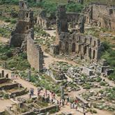
| Aspendos: The theater in Aspendos is the best preserved Roman theater anywhere in Turkey. It was designed during the second century CE by the architect Zeno, originally from Aspendos, and probably built under the reign of Roman Emperor, Marcus Aurelius. The top seats and vomitorium that allowed for extremely efficient access throughout the upper reaches of theater were primarily used as seating for women. If the theater has been well preserved to this day, it is thanks to the Seljuks who used it as palace, after completing many restorations. The Aspendos Theater is still in use today for performances, a testimony to its state of preservation. It displays the most harmonious unification of stage building and auditorium. This image depicts the June 16, 1999 Gala Concert performed by the Presidential Symphonic Orchestra of Turkey. It is the perfect environment for a musical or theatrical performance! |


| Fairy Chimneys Rock Structures Mount Erciyes, Mount Hasandag and Mount Göllüdag were active volcanoes in the geological periods. Alongside with many other volcanoes, eruptions of these volcanoes started in the Early Miocene (10 million years ago) and have continued until the present day. The lava produced by these volcanoes, under the Neogen lakes, formed a layer of tufa on the plateaus which varied in hardness and was between 100 and 150m thick. Other substances in the layer are ignimbrite, soft tufa, tufa, lahar, asy, clay, sandstone, marn, basalt and other agglomerates. Plateaus, having been essentially shaped with the lava from the bigger volcanoes, were continuously altered with the eruptions of smaller volcanoes. Starting in the Early Pliocene Period, the rivers in the area, especially Kizilirmak (the Red River), and local lakes contributed to the erosion of this layer of tufa stone, eventually giving the area its present day shape. Formation of fairy Chimneys The interesting rock formations, known as fairy chimneys, have been formed as the result of the erosion of this tufa layer, sculpted by wind and flood water, running down on the slopes of the valleys. Water has found its way through the valleys creating cracks and ruptures in the hard rock. The softer, easily erodable material underneath has been gradually swept away reseding the slopes and in this way, conical formations protected with basalt caps have been created. The fairy chimneys with caps, mainly found in the vicinity of Urgup, have a conical shaped body and a boulder on top of it. The cone is constructed from tufa and volcanic ash, while the cap is of hard, more resistant rock such as lahar or ignimbrite. Various types of fairy chimneys, are found in Cappadocia. Among these are those with caps, cones, mushroom like forms, columns and pointed rocks. Fairy chimneys are generally found in the valleys of the Uçhisar-Ürgüp-Avanos triangle, between Urgup and Sahinefendi, around the town of Cat in Nevsehir, in the Soganli valley in Kayseri, and in the village of Selime in Aksaray. |


| Kommagene: The Forgotten Kingdom, Mount Nemrud The kingdom of Kommagene was situated in the south east of Turkey, at the upper reaches of the Tigris and Euphrates rivers. Around 850 B.C. Kommagene appears for the first time in the annals of written history. According to the records of an Assyrian king, the population had to pay an annual tribute to him of gold, silver and the famous wood of the cedar trees. Apparently, the valuable cedar tree not only grew on the hillsides of the Lebanon in those days, but also in Kommagene. Kommagene became a satellite state of the Assyrians. Around 700 B.C. A Kommagenian king rebelled against the Assyrians. The Assyrian king, Sargon, defeated him. Sargon has given us a vivid description of this rebel king : " He is a godless man, who does not fear the gods. He plots only bad things and is full of cunning." We may assume that Sargons description is a little subjective. Sargon continues : " I took his wife, his sons, his daughters, his possessions, his treasures, and finally I took the population of his land and had them deported to the south of Mesopotamia (Iraq). Nobody escaped. The people of the south of Mesopotamia I transferred to Kommagene." As we see, the policy of deporting people was already excercised in those days. Around 600 B.C. The Assyrians were defeated by the Babylonians. The last battle was fought at Samosata, a town which would become the future capital of Kommagene. Here, at the banks of the Euphrates the remains of the Assyrian army had united with the Egyptian army to withstand the Babylonians. The Babylonian king defeated the united forces. The people of Kommagene saw, how in their turn the Babylonians were replaced by the Persians, around 550 B.C. And then the Persians by the Greek intruders under Alexander the Great. Around 300 B.C. One of the heirs of Alexander the Great came into possession of the land. It was King Seleukos I Nicator, who founded the dynasty of the Seleucides. He is one of the Greek ancestors of the Kommagenian kings. Around 130 B.C. Kommagene became an independent kingdom. |

| Troia, Excavation Troy (in northwest Turkey at the entrance of the Dardanelles) is one of the oldest and most famous archaeological sites. It had been thoroughly studied through two series of excavations - by Heinrich Schliemann and Wilhelm Dörpfeld from 1871-91 and by Carl W. Blegen (University of Cincinnati, Ohio) from 1932-38. The hill lies at the crossing between the Orient and southwest Europe, and between the Aegean and the Black Sea. Because of its nearly continuous occupation for more than 3000 years, this site is an important point of reference for the chronology of the ancient world from the early Bronze Age through the Roman Empire. In 1988, after a hiatus of 50 years, the excavations at Troy were once again resumed under the direction of Dr. Manfred Korfmann from the University of Tübingen, with the cooperation of Dr. Brian Rose from the Department of Classics at the University of Cincinnati. Every summer since then a large international group, composed of archaeologists as well as representatives of many other academic disciplines, has conducted excavations. |

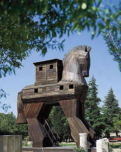
| Troy Horse The settlement mound of Troy is situated in an excellent strategic position between two continents and seas only a few kilometers from the Dardanelles on a limestone plateau. This location, in conjunction with the special conditions of the currents and winds, favored trade and cultural contacts. It is thus possible to connect finds at Troy with other archaeological sites. 3500 years of habitation on this site have left behind layers roughly 15 meters in height. When Heinrich Schliemann, following upon the preparatory work done by the American Frank Calvert, started working in 1871 on the ruins on the hill, Hisarlik (Turkish: inhabited hill/mound with fortress), he was convinced that the city of Troy/Ilium from the legendary, bronze-age Trojan War, described by Homer around 730 B.C.E., was to be sought here. Graeco-Roman antiquity had already located the city on this spot - this is borne out by the expansion of the city of Ilion as well as by the numerous tumuli which predominately served hero cults. However, this knowledge was partially forgotten in the middle ages and into the modern period. In the Bronze Age, a shallow bay stretched from the Dardanelles close to the foot of the fortress hill. Today it reaches to the edge of the Scamander s drained estuary (present Turkish name Karamenderes). The investigation of the topographical history with the drilling of over 200 test holes, together with the inclusion of the archaeological results, yields an idea of the area during prehistoric times. A complete inventory of the Troad s archaeological sites is being compiled with the aid of annual inspections. The inventory should serve as the basis for their permanent protection. |

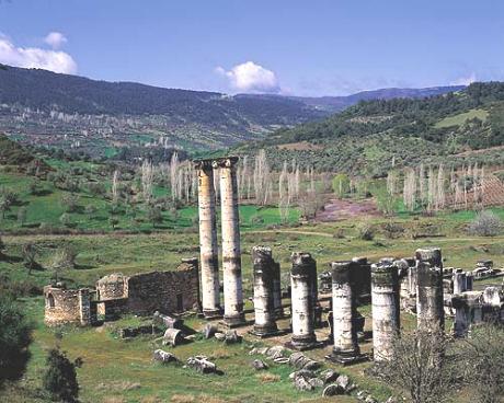
| The Aizonai Zeus Temple It is believed that the mythological hero Azan, regarded as the precursor of the Phrygians who used to live around the sacred cave of the goddess Meter Steunene in the upper region of the river Penkalas, was the offspring of the water nymph Erato and the legendary King Arkas. Most probably Aizonai, the name of the antique city, derives from the name of the mythological hero. Tile findings indicate that Aizonai has been settled since 3000 B.C. The region was part of Bergama and Bythinia during the Hellenistic period and came under Roman rule in 133 B.C. Coins dating to the 2nd and 1st century B.C. were found in this city, which was rich in oil, wine and wheat production during the Roman Empire, with a reputation going beyond city limits. But other findings indicate the first urban settlement in Aizonai dates only to the 1st century A.D. Further to the site s south, there is a round structure which is surrounded by a gallery and which was probably used as a food market in the 2nd century A.D. It is sometimes described as the first commodity market in the world. Roman Emperor Diocletian was known for the extensive reforms he introduced into the Roman Empire and for reviving the power of the empire and establishing stability of government. The reforms he introduced included a new system of taxation which was based on units of land and human beings and was liable to revision every fifteen years. He introduced new coinage in an attempt to stabilize prices; however, it seems to have led to a reduction in the value of silvered bronze already in circulation. Coinage began to be distrusted, spending became desperate and there was an abrupt rise in prices. In A.D. 301, he issued the Edictum de maximis pretiis (Edict of maximum prices) to combat these. He seems to have been somewhat less than successful, however, in these reforms, according to the entry in the Oxford Classical Dictionary. Walls dug up in 1971 revealed the edict in inscription form in which Diocletian detailed the measures to fight inflation in his territories. The inscription indicates the prices of all goods that were traded in the empire, according to which, the price of a robust slave corresponded to two donkeys, which was approximately 30,000 dinars, while a horse was worth three slaves. Further research in 1991 indicated that the round construction was once surrounded by a number of courtyards. The center of an episcopacy in the early Byzantine period, the city faded into the background in later times. During the Middle Ages, a fortress was constructed in the place where the old temple used to stand. During Seljukid sovereignty in the 13th century, it was used as a base by the Cavdar Tartars, hence its name Cavdarhisar. Aizonai was rediscovered by European travellers in 1824 and research was done on this settlement in 1830/1840. Excavations by the German Archaeological Institute under the leadership of M. Schede and D. Krencker started in 1926. This work was taken up again by R. Naumann in 1970. |


Resume
| Research
| Main Page
Carnegie Mellon University, Robotics Institute
5000 Forbes Av., Pittsburgh, PA, 15213
hulyayalcin@gmail.com
