
|
FreeWheeling Easy in Western Pennsylvania |
|
Oil Creek State Parkby Mary Shaw and Roy Weil |
We are pleased to present this section of the book FreeWheeling Easy in Western Pennsylvania. This page is a copy of the full write-up that appears in the book for the Oil Creek State park Trail.
Petroleum Center to Drake Well Museum near Titusville in Venango County
Basic Facts
Local history, attractions
Extensions of the ride
Access points
Amenities
Trail organization
Maps, guides, other references
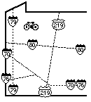 Trail map in [ GIF
format ] | [ postscript
format]
Trail map in [ GIF
format ] | [ postscript
format]
The birthplace of the oil industry supplies the setting for a ride that combines the natural beauty of Oil Creek Valley's clear trout stream and hemlock-hardwood forest with traces of the oil boom that once dominated the valley. The trail follows the path of the railroad that once carried oil from wells in this and adjacent valleys. But the intervening century has erased most evidence of the industry, and you now rely on interpretive signs along the trail and the Drake Well Museum to pick out the remaining traces.
The trail begins at Petroleum Centre near the SR1004 bridge. It shares a township road with traffic for .5 miles, then drops down to Oil Creek and crosses under the Oil Creek and Titusville Railroad. A mile later the trail crosses from the east side of Oil Creek to the west, remaining on the west side for the remainder of the trip. Shortly after crossing the creek, at northbound mile 1.7, is the marker for the historic site of Pioneer. There are also markers for Shaffer Farm (northbound mile 4.4), Miller Farm (northbound mile 5.2), and Boughton (northbound mile 7.5), but few visible traces remain. The most obvious is a rock foundation wall at Boughton. The trail continues northbound to mile 9.7; you can continue on the road to Drake Well Museum. It is well worth continuing, for traffic is light and the museum has a vast open-air collection of oil field equipment, which is sometimes operating.
The trail is asphalt-surfaced, 8.5 feet wide, with a few short hills. It is well populated with interpretive signs, views of Oil Creek, wildlife, picnic tables, benches, and rain shelters. It can be busy to crowded on nice summer weekends.
You're likely to see excursion trains of the Oil Creek and Titusville Railroad across the creek from the trail. If you want to cycle one way and ride the train back, your bike can join you on the train for $1 over your fare ($9 for adults in 1995).
Plans for the Allegheny Valley Trail system call for incorporating this trail as a segment of its Corry to Franklin leg, but it will take some creativity to get down the Oil Creek valley along PA8.
This area is the birthplace of the American oil industry. For centuries, oil occurred naturally on the surface along Oil Creek. In 1859, Colonel Edwin Drake came to the area searching for a quantity source and became the first to drill successfully for oil. On Sunday August 28, his well just south of Titusville struck oil at a depth of 69 feet. Drake Well Memorial Park is on the site of his well.
The next dozen years saw a boom and bust in the local oil industry, with development and demise of entire towns. Petroleum Centre grew suddenly to a population of 3,000 in 1863; the town of Pithole, a few miles to the east, was built between May and September of 1865 and was already vanishing by January of 1866. Both towns are now historical sites where you can visit some of the remaining traces. There were also oil fields at Tarr Farm, Pioneer and Miller Farm, along the bike trail. The Oil Creek Railroad was created to ship oil out of the valley. Miller Farm was terminus of railroad; the world's first successful oil pipeline connected it to Pithole, 5.5 miles to the east.
Oil Creek State Park provides interpretive information, including signs at many points along the trails. Additional attractions (mostly with admission fee) include the Drake Well Museum 0.4 miles from the northern end of the trail, The antique car museum 1.5 miles from the Petroleum Centre trailhead, the Pithole historical site to the east, and the Oil City & Titusville excursion train, which runs on the opposite side of Oil Creek from the trail. You may also enjoy the nitroglycerin tour in Pleasantville and the antique musical instrument museum in Franklin.
The valley continues to be an oil center: the oldest producing oil well in the country is the McClintock No. 1, owned by Quaker State and located just north of Oil City. It has been producing continuously since August 1861.
Signs at Petroleum Center indicate an antique car museum 1.5 miles east on the township road: start up the trail from Petroleum Center, and when the bike trail leaves the road, stay on the road for 1 more mile. The ghost town of Pithole (with museum) is also east of the park; the map suggests that it's accessible on back roads 2-3 miles beyond the car museum. If you find a good route, let us know.
Vicinity: Directions begin northbound on PA8 at the end of the bypass around Oil City. To reach this point from Pittsburgh, go north on I79, east on I80, and north on PA8, taking the PA8 bypass around Oil City.
South trailhead (Petroleum Centre): From the northern end of the PA8 bypass, continue north 3.5 miles on PA8 to the turnoff marked for Petroleum Centre at Oil Creek State Park. (The correct turnoff is just north of the PA8 bridge over Cherrytree Creek; do not confuse this with the turnoff for Rynd Farm and OC&T RR, which is just south of this short bridge.) Turn right toward Petroleum Centre on SR1007. Follow signs for 3.1 miles until SR1007 turns left and SR1004 goes right. Turn right and crosses Oil Creek. Trailhead parking is just ahead on the left. Alternate route: If you are coming southbound from Titusville on PA8, it's faster to reach Petroleum Centre by turning left at the well-marked intersection in Cherrytree, 5.4 miles after you cross Oil Creek just south of Titusville.
North trailhead (Drake Well Museum): From the northern end of the PA8 bypass around Oil City, continue north on PA8 for 14 miles to the stop light at Bloss St., marked for Drake Well Museum. Turn right and continue for just under a mile to trailhead parking on the right (just before Jersey Bridge over Oil Creek).
Other access: If you're truly determined to gain intermediate access, get the park brochure and follow back roads to the Pioneer or Miller Farm historic sites.
Rest rooms, water: Rest rooms and water at park office in Petroleum Centre. Latrine along trail just south of the intersection with Miller Farm Rd (northbound mile 4.9). Rest rooms and water at Drake Well Museum.
Bike shop, rentals: No bike shop; rentals Memorial Day to Labor Day, plus weekends in spring and fall at the old Egbert Oil Office at Petroleum Center (south trailhead).
Restaurant, groceries: Light snacks and soft drinks at rental shop. Soft drink machines at Drake Well Park. Groceries in Rouseville and Titusville.
Camping, simple lodging: Oil Creek Camp Resort: from west side of Oil Creek at Petroleum Centre, up Oil Creek Pike Rd (SR1009) for just over a mile, then follow signs to jog right on Pioneer Rd for .1 mile then left for .5 miles on Shreve Rd to the campground.
Swimming: No authorized swimming area in the state park.
Fishing: Oil Creek is one of the largest trout streams on Pennsylvania. It offers prime trout fishing throughout the season and is stocked by the state. Deep pools alternate with productive riffles.
[FWE Home] [ Explanations] [about the authors] Trails: [in Pittsburgh] [North] [East] [West] [full Oil Creek write-up]
FreeWheeling Easy is available in many western Pennsylvania bike shops, outdoor stores, and bookstores for $9.95+tax. If you can't find it there, you can order from us: Shaw-Weil Associates, 414 South Craig St. #307, Pittsburgh PA 15213. We have to charge you for tax and postage, so send a check for $11.93. We usually ship in 1 to 5 days. Sorry, we don't do credit cards, but amazon.com books does. You can order it from amazon.com for $9.95 + shipping, but you will pay more for shipping and it will take longer.
The material on these web pages is copyrighted. We are absolutely delighted for you to link to these pages or print copies for personal use. However, if you want to copy the material for any other use, you must ask us first.
Updated 04/12/97 by Mary Shaw
Comments to maintainer