 |
Reid Simmons, Sanjiv Singh, Tony Stentz, Vandi Verma, Alex Yahja
The Sojourner rover on Mars demonstrated some of the advantages of having mobile rovers on other planets. Sojourner, however, was mainly teleoperated, could not travel beyond range of the lander, and traveled only about 100 meters over a course of three months. NASA's upcoming missions to Mars call for rovers capable of traveling a hundred times further, and doing so autonomously. We are developing, and transferring to NASA, technologies for rough terrain navigation that will make this possible.
The scientific benefits of being able to autonomously navigate on other planets is tremendous. Using Sojourner-like techniques, navigating from one site of interest to another (typically 50-100 meters distance) might take weeks, or even months. Autonomous navigation can cut that down to a day or two. This leaves much more time for scientific data collection and rock sampling. In addition, autonomous rough terrain navigation has applications in many other areas, including agriculture, forestry, and military domains.
Current NASA rovers are able to travel short distances autonomously, but do not fare well in very rough terrain. In particular, they are able to avoid discrete obstacles, but are not good at making decisions about terrain traversability, or about planning optimal global paths through the terrain.
We are starting with navigation techniques for local obstacle avoidance developed for a prototype lunar rover [1,2] and path planning techniques developed for unmanned ground vehicles [3,4]. The Morphin obstacle avoidance system uses stereo range data to create a gridded ``traversability map'' that indicates areas of greater and lesser traversability, based on statistical measures of the roughness and slope of terrain patches. Morphin evaluates the goodness of various steering angles by integrating the traversability measures over paths generated for each steering angle. D*, the global path planner, uses the same traversability maps, but at a coarser resolution, to plan optimal paths to the desired goal location. The recommendations of both Morphin and D* are combined by an arbiter module, which sends the best steering angle and speed to the vehicle controller.
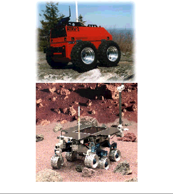
We are currently implementing the navigation system on an ATRV-2 vehicle from Real World Interface (Figure 1, left). We added stereo cameras and a Compact PCI computer to the vehicle, to make it completely self-contained. The modified ATRV-2 has the same dimensions and same computing and sensor configuration as the next generation NASA JPL Mars rover (Figure 1, right). We anticipate porting and testing our navigation algorithms on the JPL rover in the Summer of 1999.
We will extend our navigation algorithms to better analyze terrain traversability, using wavelet representations, and to better handle uncertainty in sensing and position estimation. We also intend to explore methods for landmark-based position estimation, use of multiple sensors for terrain perception, integrating autonomous science exploration and navigation, and incorporating learning algorithms to enable the rover to adapt to unexpected changes in the environment and vehicle characteristics.