
Publications
Chen, X., Zhang, H. and Gelernter, J. (2015). Multi-lingual geoparsing based on machine translation. arXiv:1511.01974
Nourjou, R. and Gelernter, J. (2015). Distributed Autonomous GIS for Automated Coalition Formation in Human Team in Urban Search and Rescue.ACM SIGSPATIAL MobiGIS 2015, November 3, 2015, Seattle, Washington, USA.
Zhang, W., Yu, Y. Gupta, O. and Gelernter, J. (2015). Recognizing Extended Spatiotemporal Expressions by Actively Trained Average Perceptron Ensembles. arXiv1508.04525
Zhang, W. and Gelernter, J. (2015). Exploring Metaphorical Senses and Word Representations for Identifying Metonyms. arXiv1508.04515
Gelernter, J., Carley, K. M. (2015). Spatiotemporal network analysis and visualization. International Journal of Applied Geospatial Research 6(2) 78-98.
Zhang, W and Gelernter, J. (2014). Learning candidate preferences to resolve location expressions in Twitter messages. Journal of Spatial Information Science.
Gelernter, J., Ganesh, G., Krishnakumar, H. and Zhang, W. (2013) Automatic gazetteer enrichment with user geocoded data. Second ACM SigSpatial International Workshop on Crowdsourced and Volunteered Geographic Information (GEOCROWD) November 5, 2013, Orlando, Florida, U.S.A.© [Gelernter, Ganesh, Krishnakumar, and Zhang][2013] This is the author's version of the work. It is posted here for your personal use. Not for redistribution. http://dx.doi.org/10.1145/2534732.2534736
Gelernter, J. and Zhang, W. (2013). Cross-lingual geo-parsing for non-structured data. 7th Workshop on Geographic Information Retrieval (GIR) November 5, 2013, Orlando, Florida, U.S.A. © [Gelernter and Zhang][2013] This is the author's version of the work. It is posted here for your personal use. Not for redistribution. http://dx.doi.org/10.1145/2533888.2533943
Gelernter, J. (2013). Effective threat detection for surveillance. IEEE International Conference on Technologies for Homeland Security, HST2013, 12-14 November, Waltham, MA, USA.
Gelernter, J. and Balaji, S. (2013). An algorithm for local geoparsing of microtext. GeoInformatica, 17(4), 635-667. Please see Gelernter and Zhang "Cross-lingual geo-parsing" for the most recent version of this algorithm.
Gelernter, J. and Wu, G. (2012). High performance mining of social media data. XSEDE'12 July 16-20, Chicago, Illinois, U.S.A. [3 pp.]
Gelernter, J. and Mushegian, N. (2011). Geo-parsing crisis messages from microtext. Transactions in GIS. 15(6), 753-773.
Lesk, M. and Gelernter, J. (2011). Use of ontologies for data integration and curation. International Journal of Digital Curation 6 (1), 70-78.
Cao, D., Qiao, X.Q., Gelernter, J., Li, X.F., Meng, L.M. (2011). Mining data correlation from multi-faceted sensor data in the internet of things. China Communications, 8(1), 132-139.
Cao, D., Gelernter, J., Carbonell, J. (2010). Automatic document filing according to user categories. Computing Science and Statistics. Omitted from these conference proceedings due to publisher oversight.
Gelernter, J., Cao, D. and Carbonell, J. (2010). Studies on relevance, ranking and results display. Journal of Computing 2(6), 7-20.
Gelernter, J, Cao, D., Lu, R., Fink, E., Carbonell, J. (2009). Creating and visualizing fuzzy document classification. IEEE Conference on Man, Systems and Cybernetics, October 11-14, San Antonio, Texas, 672-679.
Gelernter, J. (2009). Image indexing in article component databases. Journal of the American Society for Information Science and Technology, 60(8), 1-12.
Gelernter, J. (2008). Data mining of maps and their automatic region-time-theme classification. Presented at The 16th ACM SIGSPATIAL International Conference on Advances in Geographic Information Systems (ACM GIS 2008), November 5-7, 2008, Irvine, CA, USA. Published in The SigSpatial Special 1 (1), 39-44.
Gelernter, J. and Lesk. M. (2008). Traditional resources help interpret texts. Conference on Information and Knowledge Management, October 26-30, 2008, Napa Valley California, U.S.A., 17-20.
Gelernter, J. and Lesk. M. (2008). Is your map here? The 17th International Research Symposium on Computer-based Cartography, September 8-11, 2008, Shepherdstown, West Virginia, U.S.A. [13 pp.]
Gelernter, J. (2007). A quantitative analysis of collaborative tags: Evaluation for information retrieval: A preliminary study. The 3rd International Conference on Collaborative Computing: Networking, Applications and Work Sharing jointly sponsored by Create-Net, and the International Communications Sciences and Technology Association (ICST). Crowne Plaza White Plains, New York, USA, November 12-15, 2007, 376-381.
Books and chapters
Gelernter, J. (2015). Computer systems and protocols to heighten effectiveness of real-time surveillance. K.F. Hodges, Ed. New Developments in Surveillance Systems and National Security. (pp. 51-76) Nova Publishers.By editor invitation.
Gelernter, J., Cao, D., Carley, K. (2011). Extraction of Spatio-Temporal Data for Social Networks, Chapter 15 in T. Özyer et. al, The Influence of Technology on Social Network Analysis and Mining. Lecture Notes in Social Networks, vol. 6 (pp. 351-372) Springer, Vienna. [ISBN: 978-3-7091-1346-2] DOI 10.1007/978-3-7091-1346-2_15
Gelernter, J. (2011). Mining journal article components: the case of map graphics Ed. N. Tang Information Extraction from the Internet. (pp. 57-72). IConcept Press. [ISBN: 978-14563570-0-9]
Gelernter, J. (2009). Intelligent information retrieval for maps. Saarbrueken, Germany: VDM Verlag. ISBN: 978-3-639-14359-1]
Gelernter, J. (2009). Neogeography. Chapter 39 in T. Dumova and R. Fiordo (Eds), Handbook of Research on Social Interaction Technologies and Collaboration Software. (pp. 439-450)[ISBN: 978-1-60566-368-5] DOI 10.4018/978-1-60566-368-5.ch039
Presentations (selected)
Geolocation research. Human Language Technology Center of Excellence (HLT-COE), Johns Hopkins University, February 19, 2014.
Topics in Geolocation and Systems design. Center for the Advanced Study of Language (CASL), University of Maryland, February 18, 2014.
Directed looking. Visual Search Workshop Army Research Office, Washington, D.C., December 5-6, 2013.
Topics in recent research. United States Army Research Laboratory, Adelphi, Maryland, September 3, 2013.
Research overview: Geolocation and Attention. University of Maryland Center for Advanced Computer Studies, July 1, 2013.
Geolocation for intelligent law enforcement. Technology Symposium, Digital Intelligence and Investigation Directorate, June 12, 2013.
Location intelligence through mining text data. Topographic Engineering Center of the U.S. Army Research Engineering and Development Center, June 11, 2013.
Related research and our HourMap. National Geospatial-Intelligence Agency (NGA). Springfield, Virginia. June 6, 2013.
Geo-locating Twitter messages. Pittsburgh Supercomputing Center. February 28, 2012.
Georeferencing for social network analysis. Center for Computational Analysis and Organizational Systems (CASOS), Carnegie Mellon University, September 21, 2010.
Prototype of a data integration tool. Society for Prevention Research, Denver, Colorado, June 1, 2010.
Varied Applications of Ontology for Vertical Search, Information Visualization, and Data Fusion. Language Technologies Institute Seminar Series, July 31, 2009.
Methods to improve information retrieval through ontologies and visualization. Digital Library Colloquium, Carnegie Mellon University, January 14, 2009.
Research in methods to improve information retrieval. State University of New York at Buffalo. November 19, 2008.
MapSearch. Research Seminar, Google, Inc., New York City, July 2, 2008.
A new look at ontologies for information retrieval. Center for Intelligent Information Retrieval, University of Massachusetts at Amherst, May 14, 2008.
Courses designed
Introduction to Geoinformatics
Scientific writing, speaking and presentation
Introduction to large-scale text processing
Navigation for people and animals
Mentoring
These are the students and fellows who have worked with me in the School of Computer Science, Carnegie Mellon University, since 2008. A person's primary affiliation is included when the affiliation is not Carnegie Mellon. Postdoctoral fellow Xu Chen, 2013–2014 cross-lingual geoparsing Graduate students Olivera Kotevska, 2015- , Doctoral student, University of Grenoble, France, Cyber Physical Systems Han M. Zhang, 2014, Masters student, Language Technologies Institute, Machine learning Manu C. Gowda, 2014, Masters student, Indian Institute of Technology (IIT) Kanpur, geolocation for digital forensics Chaitra Radhakrishna, 2013–2015, Research Scholar, Named Entity Recognition and information visualization Wei Zhang, 2012–2014, Masters student, Language Technologies Institute, Machine learning and geolocation Priyank Mathur, 2013, Masters student, Heinz College, prototype web interface for the geoparser Haibo Wang, 2013, Masters student, toponym disambiguation Apoorvi Jain, 2012–2013, Software engineering, School of Computer Science, inattentional blindness and data analysis Chirayu Wongchokprasitti, 2012–2013, Doctoral student, University of Pittsburgh, Social networking and geolocation Shuguang Han, 2012, Masters student, University of Pittsburgh, Geoparsing Gang Wu, 2012, Masters student, University of Pittsburgh, Geoparsing Dong Cao, 2008–2010, Doctoral student, Data mining – Awarded PhD spring 2011 Undergraduate students Jyoti Jha, 2015- , IIIT Hyderabad, India, code switching; ontology evaluation Anupama Gupta, 2015- , IIT Allahabad, India, synonym clustering Yasin Ali Kahn, 2015- , Chittagong Univ. of Engineering and Technology, Bangladesh, relation extraction Shubham Sharma, 2015- , IIT, Varanasi, India, analysis of digital communications Nishtha Jain, summer 2014, Vellore Institute of Technology, Chennai, India, metonym detection Osho Gupta, 2013–2014, IIT Varanasi, India, temporal parsing Nathaniel Lyons, 2013, metaphor/metonym project Kevin Gilbert, summer 2013, toponym disambiguation Gautam Ganesh, 2012–2013, Anna University, Chennai, India, toponym extraction Hamsini Krishnakumar, 2012–2013, Anna University, Chennai, India, toponym extraction Alison Kao, 2013, metaphor/metonym project Sally Gao, 2012, inattentional blindness Wangzi He, 2012, large-scale testing on the supercomputer Shilpa Balaji, 2011, geoparsing Nicholai Mushegian, 2011, geolocation Yichao Zhao, 2010, ontology integration Matthew Goldfarb, 2009, ontology integration Laura Meng, 2008, interface design
Tools and resources
Spatiotemporal parser for fuzzy time and location expressions. Our prototype widens the definition of time to include descriptors like “simultaneously”, and “daily”, etc., and the definition of location to include descriptors like “near the end”.Prototype
Metonym Detector for Location: Our prototype determines whether the location entity found in English text represents a physical location (Champagne the region in France) or a metonymic substitution of location word for a person, organization or product (Champagne in a bottle) Prototype
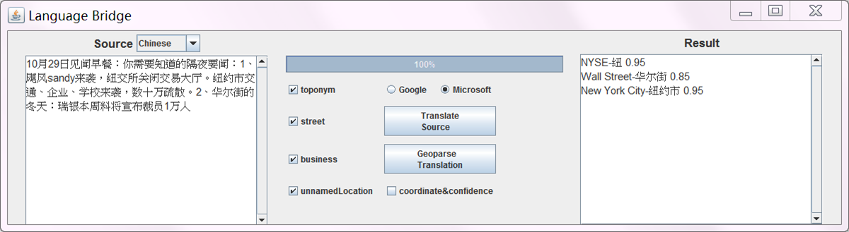
Language Bridge is a multi-lingual location-time-person extractor. It is currently set up for English, Chinese, Arabic, Bahasa Indonesia, and Russian, but dozens of other languages can be added easily. Screen shot We are working on a timemap dislay to cluster person, location and time.
Geolocator software extracts location entities from tweets and text, and attaches geographic coordinates to each location. The Geolocator 3.0 is a core component of our LanguageBridge software. Geolocator 2.0
METAL = Metaphor Extraction via Targeted Analysis of Language, software to extract metaphors in multi-lingual text. My team’s interface shows contrasts in cultural values about certain topics as reflected in metaphor. In the dislay, a flag represents the country of origin of a metaphor, and clicking on the flag displays text source. Screen shot
ORA = Organizational Risk Analyzer. It is a meta-network assessment tool developed at the CASOS lab, for which my team contributed the code for geolocation capabilities in 2011. *ORA
My background
I have done pure research since 2008 in the Language Technologies Institute in the School of Computer Science at Carnegie Mellon University. I supervise undergraduates, graduate students and (soon) a postdoctoral fellow on research in areas of geo-data mining, geo-information retrieval and visualization, and design of systems to reduce visual mistakes. My PhD in information science came from Rutgers University, where I worked with Professor Michael Lesk in a dissertation pertaining to maps. My B.A. from Yale University is in medieval history and culture, my A.M. from Harvard University is in fine arts, and my M.S. from Simmons is in information science.
Contact
Gates Hillman Center, 6416
Carnegie Mellon University
5000 Forbes Ave.
Pittsburgh, PA 15213 U.S.A.
gelern at cs.cmu.edu
Acknowledgments
I would like to thank Dr. Jaime Carbonell for his continual support and encouragement.My research has been/is being funded by: