3D Terrain Mapping Using Range Sensors
We are developing algorithms to create large, high-resolution
three-dimensional representations of unstructured terrain. Such maps are
useful for a number of robotic applications such as navigation (What is the
best route from A to B?), localization (Where is the robot now?), and
teleoperation (viewing the environment while controlling a robot remotely).
Using our current approach, we have built maps as large as 260 x 166 meters
from sequences of range data. The algorithm is built upon an earlier
surface matching system developed by Andrew Johnson. The input to our
algorithm is a sequence of range images obtained from different viewpoints.
For example, we generated several sequences while driving down a dirt road,
stopping periodically to record the surroundings with a laser scanner
mounted on the roof. First, we convert each range image in the sequence
into a triangular surface mesh. Then, in the registration step, we
determine the transformation that aligns each mesh with the next one in the
sequence. Finally, we transform all the meshes into a single coordinate
system and integrate them into a single 3D map.
Our map building algorithm provides three capabilities not found together in
any previous terrain modeling algorithm. First, we have no requirement for
an initial approximation of the transform between views or the orientation
of the sensor. Second, there is no need to detect explicit features in the
environment because we rely on local shape signatures over the entire sensed
surface. Finally, it is unnecessary to reduce the sensed data to the more
limited elevation map representation.
Our initial work demonstrated that automatically building terrain maps of
this size is possible. We concentrated on the aspects specific to map
building using ground-based sensors, including widely varying resolution,
range shadows, absence of reliably detectable features, and very large data
sets. Now, we are extending the basic algorithm and testing the limits of
its performance. We are looking at ways to determine how much overlap
between views is necessary to register the views, and we are trying to
reduce the amount of computation in the registration process by
intelligently selecting points on the terrain surface for comparison.
Details are available on the following topics:
|
|
|
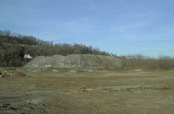
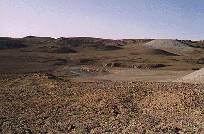
Examples of the type of terrain for which we are building maps. The slag
heap near CMU (left) and Haughten crater on Devin Island in the
Canadian Arctic (right).
|

|

|
|
The data for our experiments was gathered using laser rangefinders: the
Ben Franklin 2 mounted on Navlab 5 (left) and CMU's
autonomous helicopter (right).
|
|
|
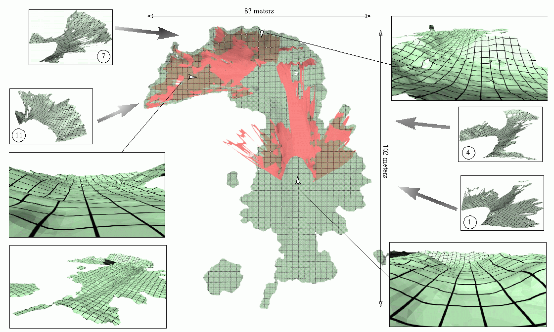
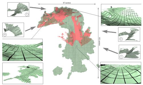
Top view of the integrated terrain map for the eleven data sets in the mesa sequence (center). The numbered insets illustrate individual data sets, and two sets (1 and 11) are overlaid on the top-view. The larger insets show various perspective views of the map, and the white arrows indicate the location and direction of the viewpoint. Grid lines are two-meters apart on the combined map and one meter apart on the individual data sets.
|
|
Last modified February 15, 1999
Daniel Huber (dhuber@cs.cmu.edu)
|