Current work
Now that we have a reliable algorithm for building maps, we are beginning to
analyze the limitations of the approach. Our next step is to
investigate how terrain shape affects the algorithm's performance. We
are pursuing two areas of investigation: intelligent selection of points
and estimation of required overlap.
Intelligent selection of points refers to the method by which mesh points
are selected for comparison in the correspondence matching phase of the
registration algorithm. Currently, points are selected at random with
the goal of evenly distributing the samples over the surface. Although
this naive approach works well for object modeling and recognition,
where the surfaces abound with interesting features. Unstructured
terrain typically contains large, featureless regions, which do not
contribute to registration. Thus, another reasonable criterion for
point selection would be an estimate of the degree a point will
contribute to the registration. By incorporating this additional
criterion into the point selection process, we intend to improve the
robustness of the current algorithm.
We are also studying the estimation of required overlap between views. We
would like to determine, based on a given data set, how much overlap is
necessary before registration will fail. By looking at the way the
surface points constrain registration for a particular area of overlap,
we can estimate in advance the probability of successful registration
from that view. This capability is a first step to the long-term goal
of an integrated planning and terrain modeling system.
|
|
|
|
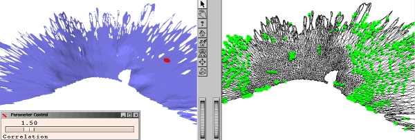
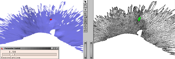
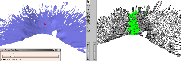
Example of intelligent selection of points: Some sample points (top) are
underconstrained. They are similar to other points spread
over a wide area of the surface. Some points (middle) are
well constrained. No other points are similar. And some
points (bottom) are constrained only in some directions.
|
|
Last modified February 15, 1999
Daniel Huber (dhuber@cs.cmu.edu)
|