

In January 1998, a differential GPS system was deployed at Patriot Hills, Antarctica, as part of a sensor validation robotics expedition. The mobile station was deployed in a sled, connected to a personal computer to record position and status data. The static station was deployed in a location close to the main camp. A radio link kept the two receivers connected to provide in-line differential corrections.
This page summarizes the experiments performed and draws inferences of the utility of the differential GPS system for autonomous antarctic robots and ground penetrating radar sensing.
The GPS differential system configuration is described. After that, simple application example of the GPS is presented, showing the physical position of the tents and other elements in the camp. Plots and statistics of the availability of satellites are shown to characterize the reliability of the system. Finally, favorable conclusions are presented regarding the use of GPS for robotics operations in Antarctica.
This configuration generated a warning in the GPS receiver every time the system was powered again. It is necessary to have a UPS or battery for permanent power for base station. That also allow for more integration time, to obtain a precise reference position for the fixed-mobile stations.
Another issue was the position of both antennas. The radio modem antennas have to be as high as possible from the snow to achieve a better range of trouble less communication. After having comms problems at a few meters distance between both stations. We raised the fixed station radio modem antenna to 2 meter high. That improved the communications to a few hundred meters. Unfortunately, it was not possible to perform modifications to the mobile station.

The GPS receiver output was transmitted serially to the sled computer
and recorded together with the information coming from the other sensors
of the sled unit. The format is :
| 00 | sequence number | unique number in one single file of GPS data |
| 01 | msec | milliseconds in the present week |
| 02 | week | weeks after GPS reference year |
| 03 | sats | number of satellites available |
| 04 | newpos | indicates a new position was calculated |
| 05 | clockfix | indicates that it got a new time update |
| 06 | horiz | horizontal position information available |
| 07 | vert | vertical position information available |
| 08 | weighted | |
| 09 | overdet | |
| 10 | ionosph | |
| 11 | filt L1 | |
| 12 | differ | differential corrections available |
| 13 | rtk | Real time kinematics corrections available |
| 14 | fixed | Fixed RTK corrections available (max accuracy) |
| 15 | widelane | |
| 16 | static | |
| 17 | null1 | |
| 18 | null2 | |
| 19 | null3 | |
| 20 | degNS | Latitude degrees coordinate |
| 21 | minNS | Latitude minutes coordinate |
| 22 | secNS | Latitude seconds coordinate |
| 23 | degEW | Longitude degrees coordinate |
| 24 | minEW | Longitude minutes coordinate |
| 25 | secEW | Longitude seconds coordinate |
| 26 | height | Estimated height |
| 27 | deltaX | Meters to the east from the base station |
| 28 | deltaY | Meters to the north from the base station |
| 29 | deltaZ | Meters over the base station |


The following graphs show the percentage of time with 3 or 4 or more satellites. There is no record for less than 3 satellites because the receivers would not output any information. However, every time the system was turned on, with the antenna clear of obstructions, the system took at most one minute to start outputting data.
Total time considered: 7.04 hours.
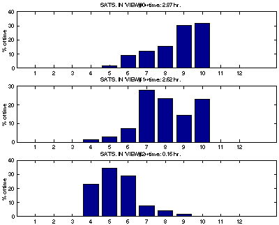

The satellite availability shows that
The scenario is the discovery of an interesting object by the autonomous explorer. The object is tagged and its GPS position is recorded. This information is transmitted to a human explorer for later assessment of the discovery.
The next figure shows the three variables (X,Y,Z) as recorded over a period of ten minutes. There is information of more than two contiguous time, but this gives a very good idea of how the position changes according to the GPS.

The variation in both horizontal axis is less than +/-2 cm. The variation in the vertical axis is less then +/-10 cm. This is enough precision and accuracy to relocate objects of the size of a small rock.
It also works fine providing position information for marking locations within centimeter accuracy. This is specially useful to mark the position of autonomous machine findings (rocks and meteorites) for later human inspection and retrieval.
The results obtained indicate that differential GPS is a useful tool for the upcoming robotics expeditions at Patriot Hills, Antarctica.
 |
|