Field Trials: |
|
What:
- Autonomous travel with guidance at boundaries of test site
- "Suicidal" instructions sent to test hazard avoidance
Where:
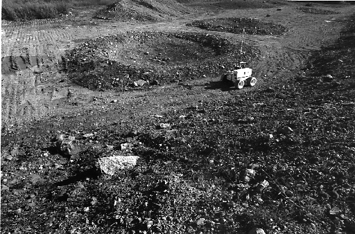
- The Moon Yard
- A carefully constructed area of lunar analog terrain
designed after the Apollo 11 and Apollo 17 landing sites.
- The Slag Heap
- A large area of diverse terrain and topography in Pittsburgh
- The REC
|
Milestones: |
|
Planned:
- On-board computing
- Laser scanner hazard detection
- Stereo with 4 cameras
- 50 km traverse in diverse, lunar analog terrain under safeguarded
teleoperation control
Achieved:
- All of the above
- Traverse 43 km under safeguarded teleoperation control
- Traverse 7 km under teleoperation control
- Total of 50 km traversal
|
Traversal
Statistics: |
|
| Traversal Distance at the Moon Yard (km) | 13.3 |
| Traversal Distance at the Slag Heap (km) | 17.4 |
| Traversal Distance at the REC (km) | 12.0 |
| Typical travel speed (cm/s) | 50 |
| Maximum travel speed (cm/s) | 70 |
| |
Reliability: |
|
Error rates:
Errors per km with stereo vision
(16 failures over 6,700 m) |
2.4 |
Errors per km with stereo vision
(36 failures over 42,730 m) |
0.8 |
|
Comparison
to 1995: |
|
| Metric | 1995 | 1996 |
Difference Factor |
| Total travel under safeguarded teleop control (m) |
13,250 | 42,730 | 3.2 |
| Typical continuous travel speed (cm/s) |
15 | 50 | 3.3 |
| Maximum continuous travel speed (cm/s) |
20 | 70 | 3.5 |
| Reliability of safeguarding (errors/km) (est.) |
- | 0.8 | 3 |
|
Observations: |
|
Strengths:
- Effective obstacle avoidance at maximum vehicle speed of 70 cm/s.
- Software system runs indefinitely long: no memory leaks.
Weaknesses:
- Recovery maneuvers after laser scanner induced stop are sometimes risky
- Laser processing is too conservative on slopes
|