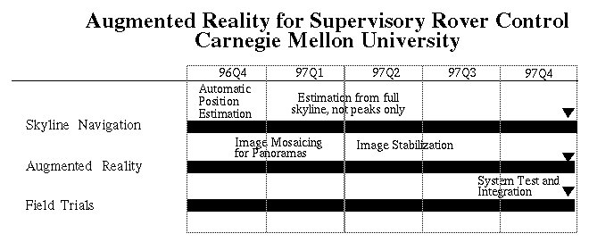
The Augmented Reality for Supervisory Rover Control task has developed technology that facilitates the control of rovers operating in distant environments. The approach augments operator displays by overlaying raw rover-acquired imagery with additional information such as topographic landmarks, heading and position estimates, and planned routes. We overlay this information in such a manner that it appears to "stick" to the terrain, independent of the rover's motion.
The task was succesfully completed during the course of the last quarter. The fourth quarter was spent in developments of image registration algorithms for image stabilization and in tests with data acquired previously.
We had finished the position estimation algorithm with excellent results in the third quarter. All results are available on the World Wide Web. Please refer to that website for more extensive document about the final status of the project.
The main effort during the last quarter was directed to:
This image may take a long time to download (approx. 1MByte)
None; task has been completed.
None.